





Estimated reading time: 4 minutes
YUGEN REALTY, SURAT
The impact of drones on construction and real estate
Drones are set to redefine how construction projects are managed, monitored, and executed. Drones can increase productivity by 50-60%, significantly reducing project timelines, costs, and skill requirements. Drone technology in construction has many advantages:
Increased efficiency: Traditional surveying is slow and labor-intensive. Drones can survey 5 acres per hour compared to 120 acres per hour with traditional methods, which helps in significant time savings and faster project completion.
Reduced Costs: Despite higher hourly rates, drone surveys are overall cheaper due to less time required. Annual costs can drop from $120,000 to $6,000, saving $114,000 for 50 surveys.
Enhanced safety standards: Drones reduce the need for workers in hazardous areas, reducing the risk of injuries and fatalities, and reducing costs related to healthcare and legal issues.
Improved data accuracy: Drones with photogrammetry provide accurate measurements and 3D maps that provide accurate, real-time data updates for better project management and fewer errors.
DroneLab: Leading the charge in drone technology

Founded in 2016, DroneLab has emerged as a one-stop solution for all drone-related needs, offering services spanning a wide range of sectors. The company’s commitment to innovation and excellence has made it a game-changer in the industry.
Nikhil Methia, Honorary Doctorate and CEO and Founder of DroneLab Technologies Pvt., is the driving force behind the company’s success. He says, “Adopting drone technology in construction is not just about increasing productivity; it’s about envisioning what’s possible for the future of our industry.”
Comprehensive solutions by DroneLab
DroneLab offers a range of services and products designed to address various challenges in the construction and real estate sectors:
Drones as a Service: Capable of providing accurate, cost-effective, and timely surveys and inspections for projects ranging from road and railway surveys to urban planning and archaeological surveys.
DroneLab Institute: Helps develop skilled manpower through specialized courses in drone technology, including powerline inspection, solar inspection, land surveying, and more.
DroneLab Store: India’s first offline store dedicated to fulfilling drone-related demands, offering products like agricultural sprayers, survey-grade drones, surveillance drones, and various software and sensors.
Application of Drone Technology in Construction
The adoption of drones in construction offers several practical applications that enhance project outcomes:
Site Analysis: Regular site surveys provide up-to-date data, ensuring efficient project monitoring and progress tracking.
Planning and Design: Drones help compare designs with as-built conditions, facilitate virtual walkthroughs to identify potential hazards, and streamline planning.
Asset Inventory: Drones effectively assess inventory and stockpiles, provide accurate measurements, and reduce worker exposure to hazardous environments.
Project reporting and collaboration: Detailed documentation from drone surveys enhances communication and collaboration between stakeholders, improving project management.
Resolving disputes: Accurate drone data helps resolve disputes by providing clear evidence of work progress and adherence to project specifications.
DroneLab’s achievements and future prospects
DroneLab’s contribution to the industry has been widely recognized. The company has received numerous awards, including the Entrepreneur of the Year Award at Start-up Fest 2023, and has established notable partnerships, such as the Drone Center of Excellence in collaboration with Gujarat Technological University.
The integration of drones into construction and real estate is not just a technical advance but a necessary evolution to increase productivity, reduce costs, improve safety, and provide accurate data. DroneLab, under the leadership of Nikhil Methia, is at the helm of this transformation that sets new standards and paves the way for future innovations in the industry.
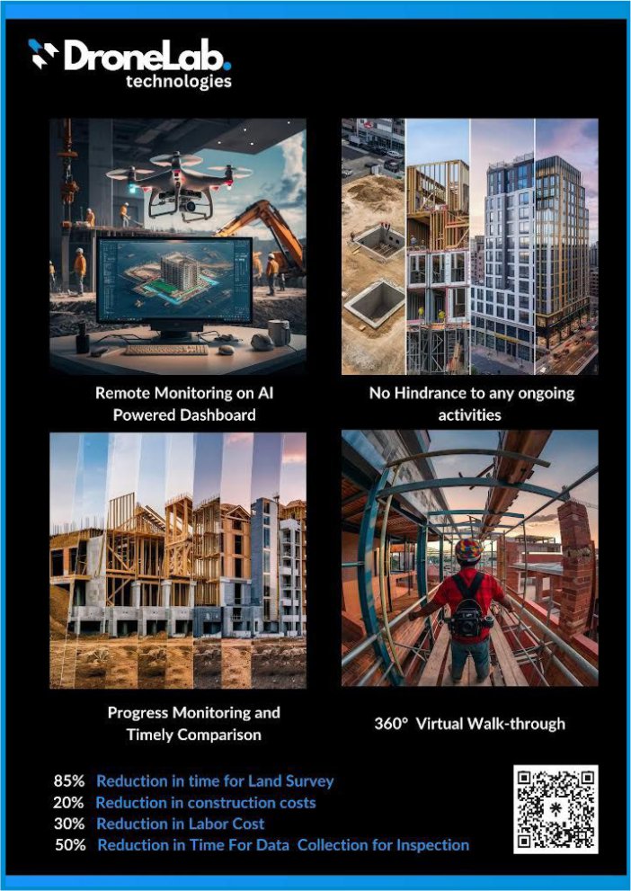
Drone Services for Real Estate:
– Building Construction
– Earthwork Tracking
– Project Progress Dashboard
– Land Survey
– Property Survey
______________________________________________________
Disclaimer : This information has been collected through secondary research and Yugen Realty Newspaper is not responsible for any errors in the same.
Read all news including local, national, international, business on Yugen Realty News. Join us on social media to stay updated with the latest news.
FACEBOOK | LINKEDIN | INSTAGRAM | X (TWITTER) | PINTEREST | TELEGRAM | WHATSAPP | YOUTUBE